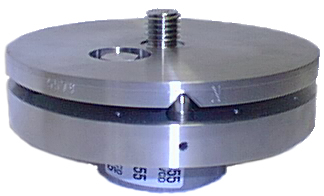
The SCIGN mount was developed for use in the Southern California Integrated GPS Network. It consists of two plates that can be leveled relative to each other. The SCIGN mount must be welded onto the monument, and must be used if also using a SCIGN dome. The mount enables north alignment of the antenna. A level and a compass are needed for installation. Used for permanent station installations only, e.g. with short or deep drilled monuments. See How to level the SCIGN mount and Instructions, References, Diagrams and Schematics Provided by SCIGN .

The SECO 2072-series leveling mount is less expensive than the SCIGN mount (~$200) and arguably as precise. The SECO cannot, like the rest of the mounts shown here, accommodate a SCIGN dome. It can be screwed onto a 5/8" thread; welding is optional. The antenna is screwed onto a brass adapter set with a set screw and can be aligned to north. A level and a compass are needed for installation. Generally used for permanent station installations, e.g. with a concrete pillar or a short or deep drilled monument when a SCIGN dome is not needed.

A simple cup with a brass adapter can be used where leveling the mount is not critical (e.g. a continuous, long-term installation where the monument is short enough that it can be installed close to level). The cup can be screwed onto a 5/8" thread. The antenna is screwed onto a brass adapter set with a set screw and can be aligned to north. A compass is needed for installation. Used for permanent and non-permanent long-term sites.
The Tech 2000 mast (Tech2K) is a portable, fixed-height antenna mount designed to be set up over traditional-style benchmarks where the survey point is a dimple. The setup is stable enough to be left unattended for months at a time. The basic design consists of an aluminum mast composed of 1-3 sections, an arrow tip at the base of the mast, a 5/8" antenna thread at the top of the mast, and three chains under tension that connect the upper part of the mast to anchor points in the ground. The arrow tip is inserted directly into a benchmark’s central point and the mast is secured and leveled by adjusting the tension of the chains. Segments allow for multiple height options. A level is included in the Tech 2000 kit; a compass is needed for installation. The Tech 2000 is lightweight and highly portable, but requires a hand drill for setting anchor points for the first site visit. Used for non-permanent long-term and campaign sites.
For more information, check out the Tech 2000 GNSS Antenna Mast page.
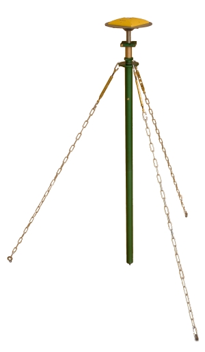
UNAVCO spike mounts are fixed at a height of 0.18 m. Adjustable legs are attached to a central brass rod with 5/8" thread at the top and a spike attached to the bottom. A level is needed and can be used on a leveling plate (available from UNAVCO) screwed onto the 5/8" thread to level the monument by adjusting the height of the legs. Loosening the legs around the central post allows alignment of the antenna to north. The mounts can be stabilized with rocks or sandbags; this setup is stable enough to be left unattended for several days at a time. For longer occupations, a bolt can be driven through a hole in the foot. Spike mounts are lightweight and compact, but may be too low to get above local obstructions such as boulders and foliage. Ideal for remote sites with minimal local obstructions. Used for non-permanent long-term and campaign sites.
See UNAVCO fixed-height 0.18m spike mount photos and diagrams .
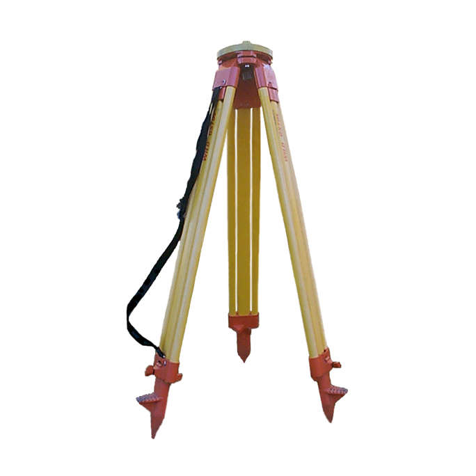
A standard tripod setup consists of an adjustable-height tripod that must be centered over the survey mark. Typically, we send out a tribrach and rotating optical plummet with the tripod to allow for sub-mm centering and leveling. A height stick must be used to measure antenna height above the survey mark. Setup error should be <1mm and stable enough to be left unattended for up to 24 hours at a time. Used for campaign sites.
Although smaller and lighter options than a tripod are available, a tripod may still be the best option for some conditions, such as a monument elevated above the ground surface (e.g. on a steep boulder) or in an area where the antenna must be elevated to obtain sufficient sky view.
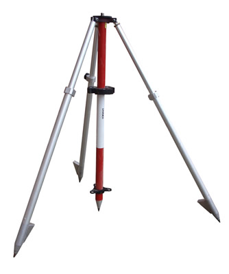
A fixed-height tripod, while lacking the flexibility of a standard tripod, eliminates both height measurement errors and the need for a height stick/measuring tape. Centering is also not needed, as the central leg fits into the marker with a spike, and leveling is accomplished with a built-in bubble level by adjusting the legs, eliminating the need for a tribrach and rotating optical plummet. Used for campaign sites.
The Trimble bipod consists of a 2-segment central pole stabilized by 2 removable, adjustable legs. The upper segment is adjustable, with the height marked on the pole. A bubble level is attached. A quick-release adapter for the antenna (shown on the system here) can be included to easily remove the antenna from the pole. The bipod lacks long-term stability and the ability for high-precision height measurements but is quick to set up and appropriate for rapid-static surveys (10-20 minute occupations).
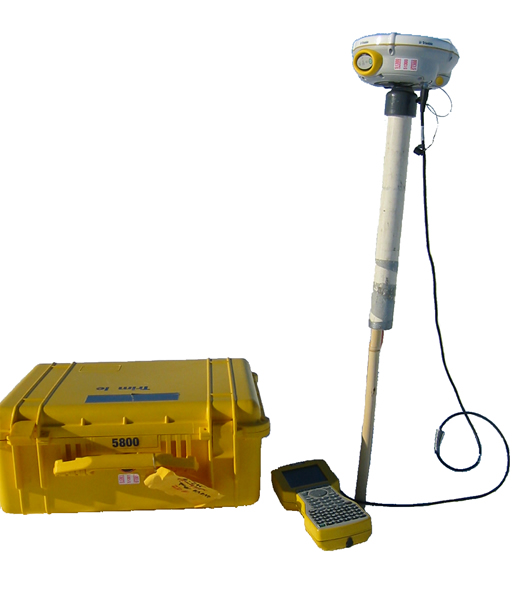
The range pole is essentially the bipod without the legs. The upper segment may be adjustable or may be fixed height. Like the bipod, the range pole includes a bubble level and can be used with a quick-adapter for easy removal of the antenna. The range pole can be used for surveys in which a precision of <1cm is not needed. Precision of <3cm for static points can be acheived. Typically, a range pole is used to map out an area or feature, to record locations (e.g. sample sites, survey markers), and/or to navigate to previously recorded locations (if surveying in real-time kinematic mode).
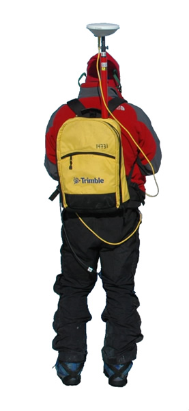
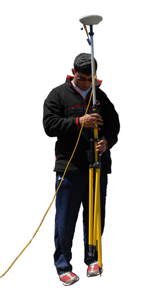
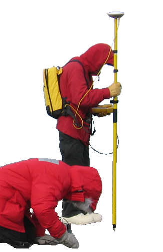
The survey backpack is the least precise but the most mobile GNSS mount option. A fixed-height pole is attached to a survey backpack in which there is room for the GNSS receiver and power. A quick-release can be attached to allow for easy removal of the antenna. The receiver is controlled via a handheld survey controller. Because of variation in antenna height depending on posture and terrain, vertical precision may be as low as 10 cm. Horizontal precision varies depending on posture as well. However, use of a survey backpack is ideal for mapping of features for which higher precision is not needed. A radio antenna can be mounted on the same survey backpack to accomodate real-time kinematic surveying.
UNAVCO can design custom antenna mounts when needed. Shown here is a PVC sleeve fitted with a 5/8" thread that slides over bamboo poles fixed into glacier ice. The glacier moves fast enough that precision of several cm is sufficient to define glacier motion. A custom mount can be designed for various goals; see also Custom Antenna Mounts and Monumentation .