)
Introduction to GNSS Antenna Set-up Methods for Campaigns
Introduction to GNSS Antenna Set-up Methods for Campaigns
When collecting geodetic data, the GPS antenna is set up over the particular point of interest. For high accuracy crustal applications, the actual survey mark is precisely defined, typically as a benchmark dimple about 1 mm in diameter in a steel pin inserted into stable ground. The monument itself is assumed to be stable relative to the solid Earth below. To avoid set-up error, it is critical that the GPS antenna is placed directly over the survey mark. The antenna must be level, and the antenna height must be properly documented. Proper antenna set-up over the mark is one of the single most critical components of a campaign survey, determining measurement accuracy and repeatability.
Antenna height is usually measured as either:
Vertical – the vertical distance from the survey mark to the Antenna Reference Point, or ARP, which is typically the bottom surface of the antenna housing.
Slant – the distance from the survey mark to the edge of the antenna chokering or groundplane notch.
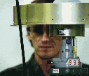
Measuring slant height on a chokering antenna.
In addition, the antenna must be set up above any local obstructions that would block or degrade the incoming satellite signals, such as rocks or foliage. When possible, the antenna should also be placed above any reflective surfaces to reduce multipath, the undesired reflected satellite signal that reduces GPS precision. The antenna height above the survey monument must be recorded accurately for data archiving and processing. Since a GPS antenna’s physical center and electronic center (phase center) may be different depending on variable factors such as satellite geometry, all antennas in a survey network should be oriented in the same direction to ensure that the measurements reflect the actual distance between monuments. The antennas will either be labeled with a (true) north arrow, or in the case of choke ring antennas orient the cable connector to true north. Use an accurate map to determine true north, or align the antennas with a compass accounting for the appropriate magnetic declination.
Several options exist for how to physically set up an antenna:
Tripods and tribrachs are commonly used to set up over traditional style benchmarks where the survey point is a dimple. The set-up is stable enough to be left unattended for up to 24 hours at a time, and is usually high enough to get above local obstructions such as boulders and foliage. The calibrated tribrach allows sub-mm accuracy. See our tripod and tribrach setup procedure.
Bipods are easier to set up, have a constant antenna height, and provide sub-cm accuracy when calibrated. However, they are less stable than tripods and are not suited to be left unattended. Bipods are typically used for rapid static and kinematic surveys.
Spike mounts may also be used to set up over traditional style benchmarks where the survey point is a dimple. The set-up is stable enough to be left unattended for several days at a time, but may be too low to get above local obstructions such as boulders and foliage. Spike mounts are best suited for remote, unattended sites with minimal local obstructions.
UNAVCO leveling mounts are specially designed for GPS survey marks consisting of a dimple within a male 5/8-inch threaded rod. The setup is stable enough to be left unattended for months. Although the leveling mounts are low, the GPS specific survey marks are usually placed away from local obstructions.