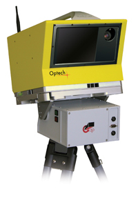
UNAVCO Summary of Optech ILRIS-3D
Retired October, 2012. No longer owned by UNAVCO
The ILRIS is a long range scanner (up to ~1500 m) and was UNAVCO’s first TLS instrument, acquired in 2008. We specially outfitted this scanner for cold weather deployment and it was a tried and true instrument for polar applications. It was deployed in non polar environments as well.
Back to TLS Comparison Table
|
TLS System
|
Min. Range
|
Max. Range
|
Repeatability
|
Power Draw
|
Field of View
|
Weight
|
Operating Temp |
|

|
Optech ILRIS-3D
|
3 m
|
1,500 m
|
7 mm |
75 W |
40° x 40° |
13 kg / 28.7 lbs |
-25°C - 40° C
|
Optech Resources
Technical Specs and Manual
Software Manuals
PolyWorks
Geo-referencing
Matchview
- Matchview User Manual (pdf) - Explains to users how to align range data with a color digital camera image.
Calculating Pit Volume
- Calculating Pit Volume (pdf) - This document provides an example of how to calculate changes in volume by creating a mesh of the object or area in question.
Software and Calibrations
Software
Calibrations
Article ID: 801
Created: February 20, 2014
Last Updated: February 20, 2014
Author: Greg Koltz
Online URL: https://kb.unavco.org/article/unavco-summary-of-optech-ilris-3d-801.html
