UNAVCO Resources: Terrestrial Laser Scanning (TLS)
UNAVCO Resources: Terrestrial Laser Scanning
UNAVCO provides Terrestrial Laser Scanning (TLS) support to Earth science researchers in the UNAVCO community. We currently maintain a pool of six scanners - summarized below - as well as supporting field equipment (e.g., GPS systems, tripods), software, and staff trained in best practices for operation of these systems. Click on the scanner for more information. UNAVCO’s TLS systems were acquired under funding from the National Science Foundation Division of Earth Sciences (EAR) and Division of Polar Programs (PLR).
For a comparison of spaceborne, high altitude, airborne, and terrestrial LiDAR systems, see Comparison of LiDAR Systems.
| TLS system | No. of Scanners Owned by UNAVCO | Min. range | Max. range | Power draw | Field of view | Weight | Operating temp. | |
|
|
RIEGL VZ-2000 | 1 | 2.5 m | 2,050 m | 85 W | 100° x 360° | 9.9 kg / 21.83 lbs | -40°C - 50°C |
|
|
RIEGL VZ-1000 | 1 | 2.5 m | 1,400 m | 82 W | 100° x 360° | 9.8 kg / 21.6 lbs | 0°C - 40°C |
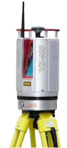 |
RIEGL VZ-400 | 3 | 1.5 m | 600 m | 65 W | 100° x 360° | 9.8 kg / 21.6 lbs |
0°C - 40°C |
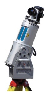 |
RIEGL LMS-Z620 | 1 | 2 m | 2,000 m | 75 W | 80° x 360° | 16 kg / 35 lbs |
0°C - 40°C |
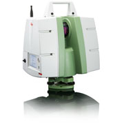 |
Leica ScanStation C10 | 1 | 0.1 m | 300 m | 50 W | 270° x 360° | 13 kg / 28.7 lbs |
0°C - 40°C |


| TLS system | Year Retired | Min. range |
Max.
range |
Power draw |
Field of view |
Weight | Operating temp. |
|
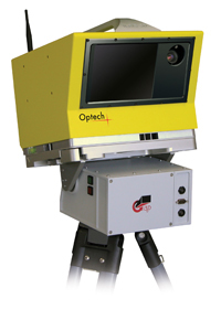 |
Optech ILRIS-3D | October, 2012 | 3 m | 1,500 m | 75 W | 40° x 40° | 13 kg / 28.7 lbs |
-25°C - 40°C |
0°C - 40°C