What is NTRIP?
What is NTRIP?
"Networked Transport of RTCM via Internet Protocol," or NTRIP, is a protocol developed by the Federal Agency for Cartography and Geodesy of Germany (BKG) that enables streaming of DGPS or RTK correction data via the internet.
There are three major parts to the NTRIP system: The NtripClient, the NtripServer, and the NtripCaster (Figure 1):
The NtripServer is a PC or on-board computer running NtripServer software communicating directly with a GNSS reference station. The NtripServer serves as the intermediary between thd GNSS receiver (NtripSource) streaming RTCM data and the NtripCaster.
The NtripCaster is a HTTP server which receives streaming RTCM data from one or more NtripServers and in turn streams the RTCM data to one or more NtripClients via the internet.
The NtripClient receives streaming RTMC data from the NtripCaster to apply as real-time corrections to a roving GNSS receiver.
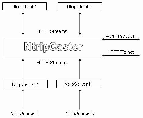
Figure 1: Schematic of a Ntrip network (Trimble, 2004).
Check out the BKG NTRIP Homepage for more information and for downloads.
For a more detailed summary of how NTRIP works, check out Trimble’s "Networked Transport of RTCM via Internet Protocol (NTRIP) - Application and Benefit in Modern Surveying Systems" (2004).